#The basin
Explore tagged Tumblr posts
Text

The never-ending churn of The Basin makes for a spot I am always awestruck with.
PRINT SHOP
#new england#new hampshire#photography#landscape photography#the basin#water#waterfall#michael j. clarke photography#outdoors#explore#print#home decor#fine art photography#usa#united states#travel
67 notes
·
View notes
Text

the basin
#the basin#littleton new hampshire#new hampshire#new england autumn#new england#forrest#mountians#white mountains
8 notes
·
View notes
Text
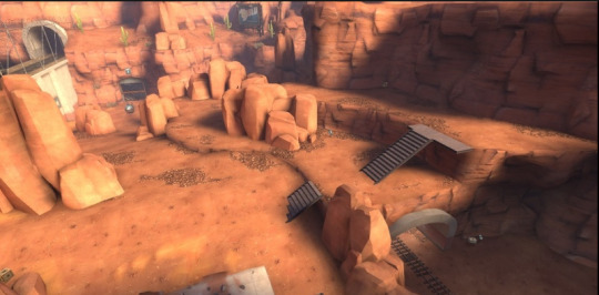
would give anything to be there rn
15K notes
·
View notes
Photo

River basins of Africa
5K notes
·
View notes
Text

The Milky Way rising above the mountains in Badwater Basin, Death Valley National Park
#death valley national park#death valley#milky way#galaxy#aimeekb#stars#night sky#astrophotography#badwater basin#hiking#adventure#explore#travel#nature#lesbians who hike#mountains#california#milkywayphotography#nebula#dark sky#dark sky park#california desert#desert
5K notes
·
View notes
Text
The Great Basin
Directly after the high peaks of the Wind River Range, there is a lower elevation desert called the Basin. 3 miles into the Basin is a historical site called South Pass City. This was an old mining town that also hosted a local representative who helped to write the women’s suffrage amendment in Wyoming, making them the first state to allow women to vote. He had worked on the article with a woman in South Pass, Esther Hobart Morris, who later became the first female justice of the peace in the United States. It was interesting to walk through the old town and see the preserved buildings and photographs. There was also a noteworthy taxidermy of two bobcats fighting that was kept in the old saloon. After leaving South Pass City, we walked out into the barren landscape, and were delighted by the rising super moon on the horizon. In the Basin, we woke up before sunrise and hiked by moonlight until we got to see the sunrise. This allowed us to log long miles in the flat terrain. Other highlights of the Basin included the spring pipes for cow troughs from which we would collect water. Cold and clear, even in this desert! The cows were pretty cute too. Some of them were friendlier than others, and would approach the water trough while we were filling our bottles. We also saw wild ponies, pronghorns, and tiny horny toads. We were lucky to get strong wind while we were in the Basin, which kept us cool during the hot, sunny days with no trees around. At night, we would try to shelter from the wind by camping on the other side of the hill. We were able to sleep with just the bug netting of the tent, and not the rain fly, which allowed for beautiful views of the full moon. Our longest day was 34 miles. Midway through the Basin we stayed in an oil town and frequent highway stop called Rollins. The hotel rooms there were only $55 and quite clean, so we decided to take a “0“ there. That meant we took a full 24 hours off trail. We ate at the surprisingly good Thai restaurant in town, hit up the local watering hole, and watched the Harry Potter marathon on TV. Owen and I had the crazy idea to buy scooters from the local Walmart, because there was a 35 mile road walk alt to finish the Basin. So as an anniversary present to each other, we bought cheap scooters from Walmart. It was terrible trying to scooter uphill, so we would put our pack straps over the handlebar and push our packs up the hill. Then, when we got to a flat or downhill, we would put our packs back on and ride the scooters! One of the days that we were out on the road, we got caught in a very cold wind and rain storm. We were pushing our scooters uphill into the weather, and it was terrible! A man stopped to ask if we wanted a ride, and unfortunately we had to decline. But he did give us some clif bars. We also met a GDT biker named Jesse who was delighted by our scooter method. He was about 80 years old and spry as all hell! He took our picture, and told us that he is redefining brilliance as “taking advantage of the obvious”. On our scooters, we had leapfrogged with our friend No Chill, who was just walking. But, when we got to the trail again, we all walked together. It was amazing to be back in the woods and on a trail! While we were in that section, Owen and I had our celebratory anniversary dinner; we had packed out tortellinis, tomato paste, and a box of Merlot. It was special and fun. We walked out of the woods and got a ride down from the pass into the tiny town of Encampment. It took a long time to get a hitch, but eventually a guy pulled into the parking lot and obliged. He had a wood covered trailer hitched to his diesel truck, and we rode in the trailer cage. It was an interesting ride that smelled distinctly of diesel fumes.
There wasn’t a lot going on in Encampment. There was a tiny hiker box run out of ammo can attached to somebody’s fence. We also hit up an antique store, went to the visitor center, and went to a restaurant. That is where we got our cheapest non-fast food burger on trail. Everyone in Encampment was extremely nice! Three or four people offered to give us rides without us asking. We coordinated with one trail angel named Janice to give us a ride after we had resupplied. The options for buying groceries in Encampment were pretty dismal. We ended up buying all of our food for the next few days from a convenience store. We also rushed to the post office in order to forward some packages to the next town. Then Janice dropped us off back at the pass, and we were off!
0 notes
Text
love that ianthe finally Won and was so proud to do her big villain monologue and explain how actually she'd been the world's most specialest girl the whole time and she was the best and her beautiful charismatic much beloved sister was just an unworthy facade of a person and she was the final boss most important real deal. only to then immediately be upstaged completely by cytherea's villain turn. and then spend the last twenty pages of climactic denouement passed out on the ground.
#tlt#marina marvels at life#okay now I need to rinse off my brain in the bathroom basin for a while. and then. silt time.
3K notes
·
View notes
Text


A tribute to my favorite quote from Hollow Knight. My biggest finished artwork so far
#hollow knight#hollow knight fanart#hollow knight art#hollow knight quote#hallownest#hallownest's crown#dirtmouth#forgotten crossroads#blue lake#City of Tears#Royal Waterways#Deepnest#Ancient Basin#Abyss#Birthplace#mask maker#delicate flower#shade lord#pale king#the radiance#it just came to me as an idea#and i really like how it turned out#that those words in particular connect with those locations#like truth about the radiance#and always with an eternal city#how the palace disappeared#will of the knight#deep#layers#kinda just wanted to practice recreating the game's style
2K notes
·
View notes
Text


Dredge location postcards by Alex Ritchie, Creative Director of DREDGE
1K notes
·
View notes
Text
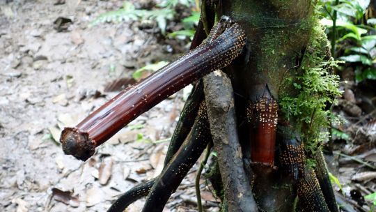
Iriartea deltoidea in the Amazon basin in Ecuador.
(Image credit: geneward2 via Getty Images)
1K notes
·
View notes
Text

The research outpost
Hermittober #7 - Shimmer
#ocean goes shimmer#love the Stellar Basin inspired builds gem has been doing#hermittober#hermitcraft#hermitcraft fanart#geminitay#geminitay fanart#amararala art
546 notes
·
View notes
Text


badwater basin
#when you leave your tripod in the car but gotta try the pano anyway#landscapes#landscape photography#photography#photographers on tumblr#original photography#mine: photos#desertcore#desert#nature photography#naturecore#death valley#death valley national park#mojave desert#national parks#badwater basin#badwater#sunset
854 notes
·
View notes
Text


its been probably four years since i'd drawn any of the stardust crusaders so i wanted to see what they'd look like in my style now :D
#if you're wondering why last week's basin update was only one page it's because i put sdc on as background noise and got distracted. sorry.#btw i drew iggy with the star on his head because my family had bostons with those markings! i just think they're neat.#my art#artists on tumblr#stardust crusaders#sdc#jjba#jotaro kujo#noriaki kakyoin#joseph joestar#muhammad avdol#jean pierre polnareff#iggy the dog
452 notes
·
View notes
Text

1K notes
·
View notes
Text
I made a little clothing guide for some Dragon Age regions
Some may not be exactly the same as the references that appear in the game or in the concepts, but I wanted to give a little of my vision to the guide.
Ferelden
Ferelden is close to the Frostback Mountains and Orlais and as Leliana and Zevran once said, Ferelden is cold, so I thought it would be a cool idea to put on thick clothes with a lot of fur so the Fereldans can protect themselves from the cold.

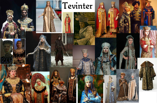
Tevinter
Dragon Age 4 is approaching and it's already evident that we're going to be in the Tevinter Imperium, so I discovered that a lot of Tevinter clothing was inspired by clothing from the Byzantine Empire
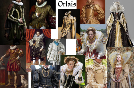
Orlais
We've already seen in the game and in the concept art that Orlais is all about being flamboyant and flashy and what's more flamboyant and flashy than mid-1500s fashion?
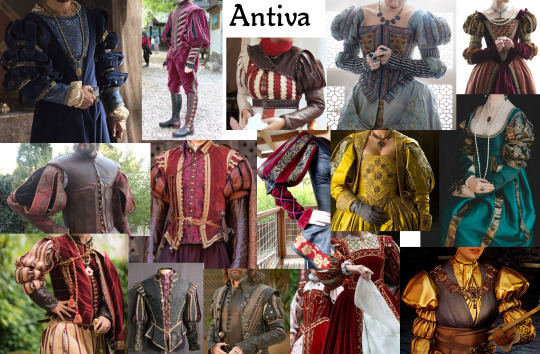
Antiva
Home to the two loves of my life, Zevran and Josephine, Antiva fashion is something I really love… The puffy arms, the breast-enhancing corsets, the leather vests, idk, I just like Antiva
Nevarra
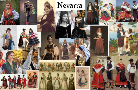
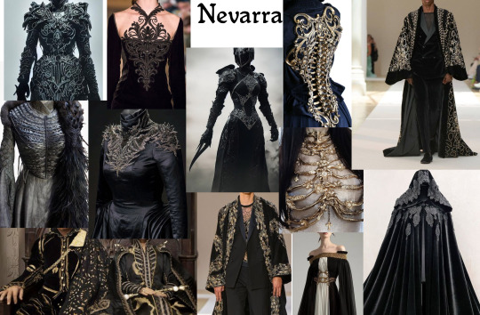
I don't exactly have much to say about nevarra, but I did some research and found some concepts that I thought were interesting, I also saw in some places that said that the kingdom was inspired by the traditional culture of Spain
So I'll leave two references here
One for the traditional clothes and one for what I imagine might look like Nevarra dress
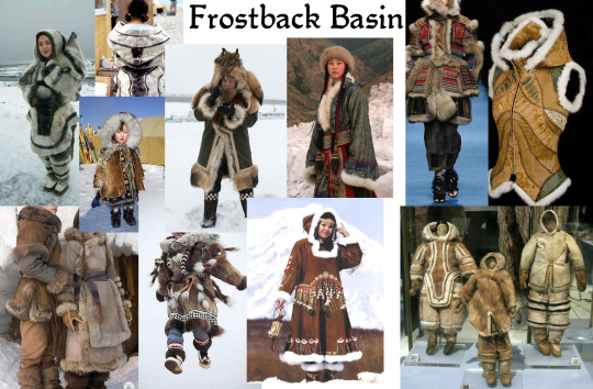
Frostback Basin
In Inquisition we can see that the clothes they wear are quite furry and well protected from the cold, so I think it would be a good idea to inspire some of their clothing in Inuit clothing
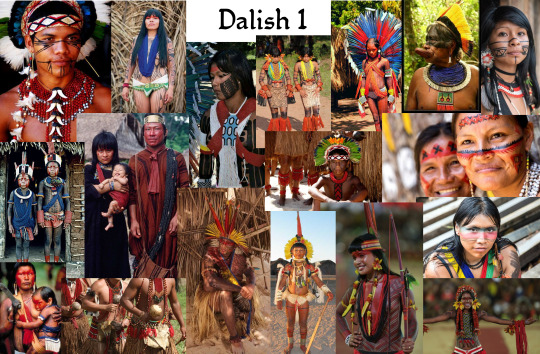
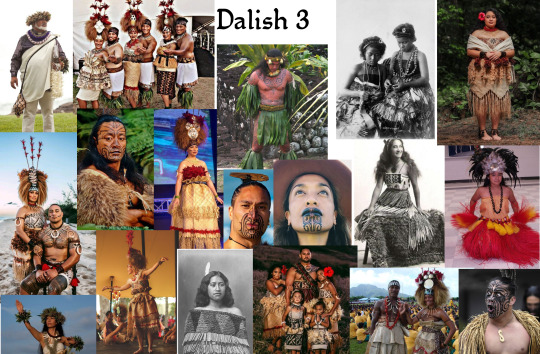
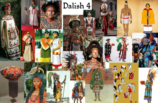
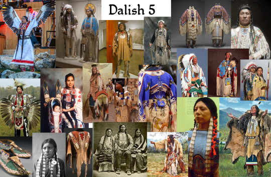
The Dalish (1/2/3/4/5)
Well, for the Dalish I had MANY ideas, among them think about adding traditional clothes from some tribes, native Brazilian/American, African, Hawaiian, Inca, Aztec and Mayan
Remembering that I made a great mix of traditional clothes from several tribes and not just one, and that I also have 0 intention of disrespecting any of them, if I have put something wrong or disrespectful you can be free to alert me

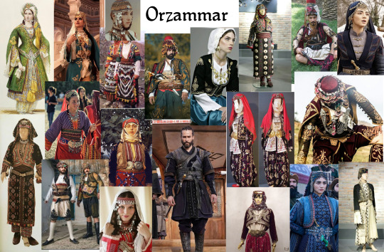
Orzammar
I knew little about Turkey, but when I went to research I ended up enchanted with some of the traditional clothes when I went to research about it and I thought that this style would go well with Orzammar
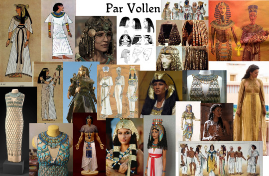
Par Vollen
For Par Vollen, I had a bit of trouble finding it, but I think clothing a little bit closer to the ancient Egyptian style would be something interesting. The light fabrics, the golden jewels adorning the body, idk, I like that idea
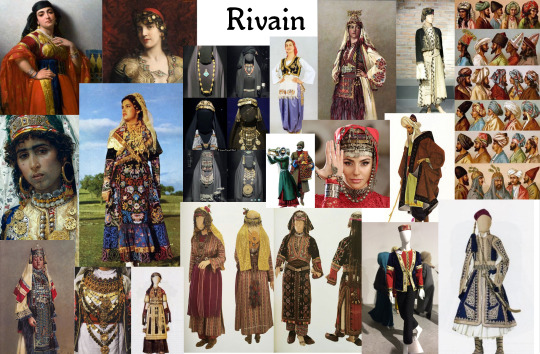
Rivain
I was doing some research again and found that part of Rivain's look was inspired by traditional clothing from Islamic Spain and Southeast Asia , so I looked around a bit for something to put here and add one more kingdom to the list
I hope you people enjoyed! Soon I will add more realms as soon as I finish my research
#dragon age fan art#dragon age 2#dragon age origins#dragon age#dragon age awakening#dragon age inquisition#tevinter#orlais#ferelden#frostback basin#antiva#nevarra#Rivain
5K notes
·
View notes
Text

New locale – Oilwell Basin
The Oilwell Basin is a new locale where the expedition team arrives. As the name implies, the area is brimming with oil wells, which will periodically burst into violent flames.


A region of dense oil wells and at times, raging fires. The harsh conditions of this locale has lead to it being inhabited by monsters and endemic life that have adapted to its unforgiving environment.

#Monster Hunter#monster hunter#monhun#monsterhunter#mh#モンスターハンター#モンハン#monsterhunterwilds#monster hunter wilds#mhwilds#MHWilds#oilwell basin#spoiler
237 notes
·
View notes